
The Federal Aviation Administration will replace existing air traffic control procedures in Southern California with new satellite-based procedures as part of its Next Generation Air Transportation System.
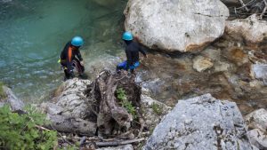
The Department of Homeland Security Science and Technology Directorate’s First Responders Group is creating software designed to help search-and-rescue groups. In a partnership with dbS Productions, FRG developed FIND to track lost individuals, some of whom may be children or people with disabilities.

With the implementation of a robust Geographic Information Services (GIS) to provide mapping and analysis services, the city continues to further “smart city” and IoT initiatives across the nation.

Jon Froehlich at the University of Maryland is working with a team of graduate students on Project Sidewalk, an online tool through which users can view their Washington, D.C., neighborhoods with Google Street View and label areas that may be inaccessible to those with impaired mobility.

CommonWell Health Alliance announced that members will be giving patients access to their health data for the first time via the CommonWell network, a not-for-profit trade association of health IT companies working together to create universal access to health data nationwide.

The Medical Group Management Association 2016 Cost and Revenue Report, released in August 2016, found that IT costs have increased by more than 40 percent per physician since 2009.

To combat economic troubles, state, regional, and local governments are looking to an unexpected industry–high-tech statups. Alaska, which has been losing jobs in mining and logging, is among those states.

The Department of Transportation on Thursday launched its National Transit Map, which includes transit data, a participation map, and interactive mapping apps. The map includes data from 270 transit agencies that provided information on more than 398,000 stops and 10,000 routes. “Measuring connectivity starts with having good data about where America’s transit connects–where transit stops […]
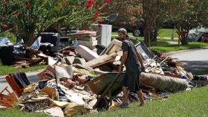
The Baton Rouge Department of Information Services on Aug. 19 created an interactive map to track damage as the Louisiana city dealt with disastrous flooding. Within hours, 10,000 people, including rescue teams, had used the map.

The National Institutes of Health announced the winners of the Design by Biomedical Undergraduate Teams Challenge, which included designs for smart pills and disposable sepsis detection chips.