
Seattle hosted its “City for All” hackathon, which gathered data scientists, designers and urban planners, and software developers to search for solutions for challenges connected to aging and accessibility within the city. The hackathon was hosted in partnership with the Age-Friendly Seattle initiative, part of Seattle’s commitment to residents of all ages, including senior citizens who wish to age in place.

The North Carolina Department of Transportation announced a deployment of analytics software that is expected to improve customer service and reduce costs across the department. The NCDOT chose to partner with SAS to deploy its SAS Platform, including SAS Viya.

Missouri and Arizona are tackling water safety with a new online compliance wizard that can benefit all states. The new wizard helps cities and other localities navigate environmental standards during water system and infrastructure upgrades.

This August, Charlottesville, Va., residents will have greater access to government salaries, traffic information, environmental data, and police statistics, thanks to a new open data portal from Smart Cville, which is a nonprofit, citizen-driven organization that promotes the use of technology to make cities better places to live.

Some states refused to turn over voter data to the White House on June 30, saying that the data requested contains sensitive information and could be used for political purposes. President Donald Trump signed an executive order in May that established the Commission on Election Integrity, which investigates instances of potential voter fraud. The commission asked the states to turn over all publicly available voter data.

More than 3,000 constituents have accessed the newest iteration of Pinellas County’s open data platform, according to Bryan Zumwalt, Enterprise GIS Manager with the county’s government.

The Montgomery County Planning Department’s open data map has garnered 455 comments suggesting improvements for Maryland’s bicycle paths. The Bikeway React Map allows people to indicate areas where certain projects, such as separated bike lanes, could be useful. Responders are contributing to the county’s larger Bicycle Master Plan, which aims to improve the bicycle network with features such as cycling lanes and bike storage facilities at transit stations.

The District of Columbia’s utility service released an interactive open data portal to share information regarding DC Water’s operations and projects with the public. The utility service is hoping that increasing transparency will improve customer satisfaction.

During the process of creating the Colorado Trail Explorer, an interactive open data map providing information on 17,000 trails, Colorado’s Department for Parks and Wildlife sent out a call for information from all 221 of the state’s trail managers. The map, launched on June 2, contains data submissions from 90 of those managers.
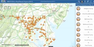
Maryland’s Department of Transportation and State Highway Administration launched e-Road Ready Projects, a live GIS map portraying major projects that have the potential to create congestion.